Biddenden Churchyard Map and Grave Locator
Last Updated on August 8, 2024 by admin
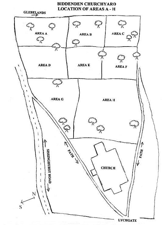
This page is intended to help visitors to All Saints Biddenden locate a particular grave within an area of the churchyard (this information is also available as hardcopy in the church during opening times).
How to use this page
Start with the Alphabetical list using the link below to find your relation by surname. Note their grave’s number and area letter A-H. Go to the map and click the letter to bring up a sketch of that part of the churchyard and locate the grave number. This can be downloaded and printed to aid identification in the churchyard itself.
If you are unable to come to Biddenden in person, use the numerical list, together with the grave number, to read the inscription on your relative’s grave stone.
Alphabetical list with numbers and areas
Numerical list with inscriptions
Please note that the link between each area and its enlarged sketch will work best on full-size screens.
This work concerns the 500 or so most recent graves and was compiled by Angie Joy during the year 2010. The grave numbers were generated by Angie’s database system and do not correspond to numbers on any graves or burials register, or to the numbering system created by Leyland Duncan during an earlier mapping project carried out in the 1920s.
While there is plenty of overlap with the burials register of 1877 to 1992, some graves dating from this period are not mentioned in the register. Conversely, some people listed in the burials register don’t have a corresponding grave in the churchyard. It is possible that some people were buried elsewhere after having a funeral service in the church. It is also likely that traces of graves without headstones have disappeared into the earth: aerial photographs show disturbance consistent with rows of graves that can’t be seen from the ground.
In 1920 Leyland Duncan did this work for a different part of the churchyard closer to the church. Some of those graves are now illegible and without his work their information would have been lost. He has his own numbering system — it will be the work of a future project to merge the two systems. Leyland Duncan’s work (including maps) is available in a folder in the church, see Visitors page for opening times and days. It is also available, not including the maps, here.
This work is a snapshot of the most recent part of the churchyard as it was in the year 2010 – very recent graves may not be included. While every effort has been made to cross-check information and ensure accuracy, mistakes can still occur. Please contact the parish office if you have corrections or additions to make.